

Freedom Mapped: The Geography of Resistance
Files
Description
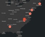
My project is called “Escaped Enslaved People and the Geography of Resistance.” Through this project, I mapped real escape stories to show how enslaved people used geography (rivers, forests, cities, and borders) as tools to resist slavery from 1827 to 1898. As I worked on this map, I became deeply fascinated by how complex and intricate the Underground Railroad truly was. Seeing the map laid out, it became clear that these escapes weren’t random, they were strategic, intelligent, and deeply organized. Unfortunately, this part of history has often been overlooked or watered down, especially in textbooks. It made it seem like Black people were helpless, illiterate, or incapable. But studying these real maps, routes, and stories proves that enslaved people showed incredible intelligence, resilience, and courage, using geography almost like a weapon against a system built to trap them. Today, I’ll walk you through eight different points on my StoryMap that show how space, time, and resistance were all connected.
Publication Date
5-3-2025
Relational Format
article
Recommended Citation
Davis, Tegan, "Freedom Mapped: The Geography of Resistance" (2025). Digital and Public History Student Projects. 35.
https://egrove.olemiss.edu/dighist/35