

Projects of the UMSRG
Files
Download
Download Full Text (289 KB)
Description
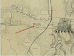
Campus maps have helped us identify several buildings that may have been used as living space for enslaved people and servants from the 1850s to the 1890s. But the search for such data netted information about the surrounding area as well.
Publication Date
12-1-2016
Relational Format
report
Recommended Citation
University of Mississippi. Slavery Research Group, "Maps" (2016). Projects of the UMSRG. 2.
https://egrove.olemiss.edu/umsrg_projects/2