

Digital Scholarship Showcase
Mapping Memphis
Files
Description
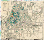
“Mapping Memphis” is a spatial humanities project that analyses how historic geographic data can offer new insights into urban heritage and community. It does so using a primary source largely underrepresented in digital humanities research: funeral home ledgers. From 1904-1929, T. H. Hayes and Sons Funeral Home, the oldest African American owned business in Memphis, Tennessee recorded demographic and funereal information for over 4,000 African American individuals. This project focuses on the physical locations recorded in each entry that inadvertently offer a glimpse into the decedents’ homes, offices, and community spaces in early 20th century Memphis. It plots these individual locations onto a digital map, creating a visual representation of Black Memphis’ social and physical layout a century ago and exploring the depths of information that can be pulled from this unique resource.
Loading...
Publication Date
4-4-2024
Relational Format
Video Recording
Recommended Citation
Norris-Davidson, Abbie, "Mapping Memphis" (2024). Digital Scholarship Showcase. 2.
https://egrove.olemiss.edu/dsshowcase/2
Accessibility Status
Audio or Video Captioning
Comments
The website for Mapping Memphis can be found here. More information on the project here.